Geography Class 19
Geography Class 19 [17:10:00]
A brief overview of the previous class i.e. Landforms of riverine topography
Karst Topography/ Limestone topography [17:25:00]
- [* If Fresh water is 100 units then 67-68 units are ice caps, 30 units are groundwater, 1-1.5 units are water vapor, and 0.3 units are water in rivers, lakes, etc]
- Underground Rock systems are called Aquifers
- When water (Containing carbonic acid) falls on the surface, It melts the rocks very easily. It will sip in and joins the groundwater
-

- This term was used in Eastern Europe, erstwhile Yugoslavia.
- Many large Caves are found- in erstwhile Yugoslavia, countries of Southeast Asia[Thailand, malyasia], Meghalaya, Mexico - Yucatan peninsula [The meteorite fell here led to the extinction of the dinosaurs, Mayan civilization flourished here, devoid of surface Fresh water, they survived through the Karst topography], Western Australia, In India these are found in Meghalaya
-
Topography Processes Erosional features Depositional features Karst/ Groundwater Conditions that led to this karst topography
- Soft and Permeable rocks in the upper layer of lithosphere such as limestone, dolomite
- Moderate to heavy precipitation
- Hard strata of rocks at the sub-surface level
Processes
- Corrasion
- Corrosion
- Attrition
- Carbonation
- Hydrolysis
[Less hydraulic action, No or less attrition ]
Features
- Sinkholes are created- very wide and huge depression
- Swallow hole- Shallow version of sinkholes
- Doline- Sinkholes merge together to form Doline
- Uvala- Dolines merge together to form Uvala [Refer to the below diagram]
- Blind valley/karst valley- The river disappears and only valleys are visible, the rivers flow underground.
- Caves- Ground water creates caves Example- Mexican caves, Meghalaya caves
Features
- Stalactites- These develop from the roof from the dripping water
- Stalagmites- The deposits develop upward from the floor.
- Cave Pillar- When both the stalactites and stalagmites meet.
[Important activity- Cave diving]
Regions Erstwhile Yugoslavia, South-East Asia, Meghalaya in NE India, Mexico, Western Australia
Marine Topography [18:15:00]
- Agent- Waves
- Source of energy- WInd (Driven by sunlight due to differential heating)
- Erosion and deposition are dependent on the type of coast
- If forward force is more then it will lead to erosional features whereas if backward force is more then it will lead to Depositional features
- On the eastern coast deposition happens and on the Western coast erosion happens (The exception is the Kerala coast)
- Processes- Corrasion, Attrition, Cavitation, Corrosion, Hydraulic action (No deflation, no plucking)
Erosional features
- Cliffs- Near to coastal region [due to erosion-steep slope]
- Wave cut platforms- Upper part is eroded but the lower part is not eroded [The lower part is hard rock], a platform is left due to differential erosion
- Bay- Too much erosion on the inner side, and wave action is more. And it creates a semi-circle shape [Differential erosion] {* Gulf is not a part of marine topography, it is a waterbody+ Gulf have narrow mouth or elongated mouth. For example- the Persian gulf, and Mexican Gulf}. When the Mouth of the Gulf is too wide then it is called a Bay. Example- the Bay of Bengal, Hudson bay.
- Hanging valley - It is a river valley that ends abruptly into the coastal region. That river valley is hanging into the ocean. For Example- Found in Norway.
- Sea caves- Due to continuous waves hitting the cliffs, creates caves from the seaside
- Sea arch or natural bridge- Development of sea caves from both sides, Gradually it will deepen and merge together. When two sea caves merge together it is called a sea arch.
- Sea stack- When the roof of an arch is broken by erosion or under its own weight or due to any other reason a part of the original rock remains standing as a solitary mass. It may be the rock forming the side of the arch. This type of feature is called a sea stack.
- Sea stump- The smaller version of the sea stack is called the sea stump
- Blow holes- When a powerful wave hits, it creates a hole in the upper part. Then the water comes out from the blow holes
-

Depositional features
- Wave-built platform- When the sea recedes and due to the deposition of sand a platform can be built, for Example- near the bay
- Beach- Where the wave speed reduces and the deposition of sand is more. In India, along the eastern coast, we have more no. of beaches [The longest is Marina beach, Chennai]
- Off-shore sand bars-When the slope is less and the water level is also less, then it creates the feature of sand bars. Sand bars not connected to the land are called offshore sand bars [Mostly found on the East coast, one of the sand bars is strategically located in Sriharikota (ISRO satellite center, on Pulicat lake)]
- Sand spit- When the sand bar is connected on one end with land
- Tombolo- When the sand bars are connected on two sides with the land.
- Lagoons- A lake near the coastal region is called a lagoon. It is separated from the main part. [* Kerala state is known for the backwaters, houseboats, etc]
-

Arid/ Desert topography [19:10:00]
- Agent - Wind [It is more of physical weathering due to sunlight], Erosion [Wind is at very high speed, as there is no vegetation]
- Erosional Process involved- Attrition, Abrasion, Deflation (Lifting action of wind) [No corrosion, cavitation as they require water], No plucking
- [* Reasons for Desert formation- Low precipitation less than 25 cm]
Erosional features
- Deflation hollows- The hollows or empty spaces created by the winds. These are created by Deflation
- Ventifacts- Abrasion causes the polishing of the surfaces, and the polished surfaces are called ventifacts
- Mushroom Rocks- Rocks near the surface go faster weathering than the above one [Wind action is faster, as sands carried by the wind are below], this creates the mushroom rocks. (Caused by Abrasion near the surface)
- Zeugen- Continuous layer of hard and soft rocks in a Vertical direction, Soft rocks will easily be eroded. Differential erosion will lead to Zeugen. It is caused by abrasion
- Yardungs- When differential rocks are there in a horizontal position.
- Inselbergs- Remanant of hills. In the central part, the hard rocks are there which take a longer time to erode.
Depositional features/ landforms
- Sands are more in the desert because of attrition
- Sand dunes- famous beaches- Thar desert [Marusthali], Ladakh [Nubra valley- Hundar sand dunes], Arabian sand dunes [Rub-al-khali sand dunes], Namib desert [The largest sand dunes are in Namib desert]
- Barchans- crescent-shaped sand dunes are called barchans. If the limbs are in the direction of the wind
- Parabolic-shaped sand dunes- if limbs are opposite to the direction of the wind
- Seif- Barchan with one limb
- Transverse sand dunes- Perpendicular to the direction of the wind
- Longitudional sand dunes- Parallel to the direction of the wind
- Bolson lake/Playas lake- Refer to the diagram [Above]
- Oasis- Fertile land around the playas region
- Pede-plain- Pediplains are formed when high relief features in deserts are lowered to low featureless plains due to wind activity. The convergence of pediments forms a Pede-plain, which is a largely flat landscape
-
.png)
Glacial Topography [19:39:00]
- Formed along the mountain sides,
- During winter- when snow is deposited on the mountain sides, a thin layer of snow is created. Where there is more depression, more accumulation of snow occurs. Water will sip into the gaps of the snowflakes and it will get harden. Through continuous melting and freezing, it becomes a thick block of ice
- During summer- The entire block of ice will start to melt from its base. It will start to move. It has a very high erosional capacity
- Agent- Glaciers [Capable of movement, largest force]
- Process involved- Abrasion, plucking, erosion
- [* 5 Big lakes are the result of glacial erosion]
Erosional features
- Nivation hollows- Small depressions where the glaciers start to build up [from mountain size to huge glacier]
- Cirque- Continuous circulation of the glacier, enlarged depression
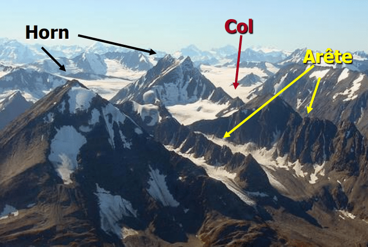
- Arete- It separates two Cirques
- Horn- When cirques are developed from all sides, and the top mountain becomes too narrow and steep. For example- Matterhorn [Alps mountain], Kailash mountain, Mt. Everest
- Col- When the horn is entirely eroded and the upper part is removed. Indira col [North of siachen]
- U-shaped valley- It is the valley created by the glaciers. When multiple glaciers merge together.
- Hanging valley- Small U-shaped valley merging with the big U-shaped valley.
- Fjords- The U-shaped valley directly enters the ocean [Norway is known for Fjords]
-
Depositional features
- Moraines- Unstratitifed mix of sand and ice carried by a glacier- lateral, medium, end moraines, and at the base is called Ground moraines
- Moraine capped lakes- When these lakes outburst it is called GLOF [Glacier lake outburst flood- example- Chorabari lake- north of Kedarnath]
- Tillites- It is a heterogeneous mixture of Clay and Till from pre-historic times
- Drumlins- Semicircle depositions are called baskets of egg topography or Drumlins
- Esker- When it is forming a longitudinal ridge it is called Esker
-
The Topic for the next class- Climatology.